
Halfway picks in the public domain
Shown in his water flood application
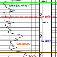 While applying for a water flood approval, this applicant also submitted his net pay map, structure map and type log with his formation picks. He showed his well density and stated his reserves. For the astute offsetting exploration geologist, this is huge competitive information.
Each AER application contains your neighbor's perspective on the exploitation of oil and gas formations. Applications contain more technical data even than SPE papers.
Would you like to see what other operators in your areas are thinking about seismic, multifractured wells, polymer schemes and recovery? AppIntel can help.
Subscribers can view this application by pasting the following link into their browser after logging into AppIntel. app.appintel.info/AOW.php?pxnrg=55756n383332353o3231374v49
Tags: Seismic, Flood, Exploration
 Granger Low 14 Sep 2015


Let AppIntel AI watch this CO2 dispute for you
19 new developments today

Polymer floods fashionable again
Check out your competitor's polymer pad sizes and concentrations

Give us more flexibility in thermal schemes!
Reducing thermal heavy oil scheme red tape

ER schemes are hot right now. Here's the catch.
Cheap capital, fast reserves – but only if you get it right
 Calgary, Alberta, Canada
 Share
Share